
TWIAV - Tips & tricks
Geographic data
On this page you will find some sample data. The data provided here is in the MapInfo Professional TAB file format.
All the files offered here are composed by the author of the website, based on publicly available source data. So please feel free to use the data - but do not forget to acknowledge the original source.
If necessary, you can download a free evaluation version of MapInfo Professional (30 days) or the free MapInfo ProViewer to view the data.
MapInfo Professional and the Dutch SDI: a free geocoding tool for the Netherlands
The zip file contains the application PDOK.MBX.
This application is an add-on for MapInfo Professional to access digital geographical data via official PDOK webservices in the Netherlands.
For more information about the Dutch Spatial Data Infrastructure (SDI) and PDOK please refer to this website.
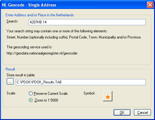
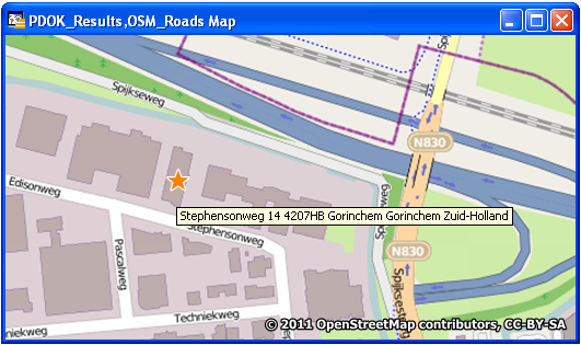
This beta version of the application PDOK.MBX (version 0.30 Beta) contains a function to directly geocode an address from within MapInfo Professional (see screendumps below).
This version of PDOK.MBX is available for free and 'as is'.


MapInfo Professional en PDOK: een gratis geocodeer tool voor Nederlandse adressen
In het zip bestand vind u de applicatie PDOK.MBX.
Deze applicatie is een extensie op MapInfo Professional voor het verkrijgen van toegang tot digitale geografische gegevens via de officiële PDOK webdiensten.
PDOK = Publieke Dienstverlening Op de Kaart
Deze beta versie van de applicatie PDOK.MBX (versie 0.30 Beta) bevat een functie waarmee u direct vanuit MapInfo Professional adressen kunt geocoderen (zie schermafdrukken hierboven).
Deze versie van PDOK.MBX wordt kosteloos en 'as is' ter beschikking gesteld. Wij horen graag uw .
Geographic Data - France
The zip file below does contain three MapInfo tables with information about France: Departments, Capitals and Rivers. Please see the Readme file for more information.
Are you looking for more data about France? Please have a look at the website of the French Institut Géographique National (IGN); they have some nice data which you can download for free.
Geographic Data - The Netherlands
NL_Municipalities2012.TAB
The file does contain a map with all the municipalities in the Netherlands, with statistical data connected to these municipalities (Status: January 1st, 2012). The data comes from the Dutch national statistical office (Centraal Bureau voor de Statistiek / see their website: http://statline.cbs.nl/) and the map does come from the Dutch Land Registry Office (Kadaster).
You can use these data freely, but you have to acknowledge the source.
Source: © Kadaster / Centraal Bureau voor de Statistiek, 2013
NL_Municipalities2010.TAB
The file does contain a map with all the municipalities in the Netherlands, with statistical data connected to these municipalities (Status: January 1st, 2010). The data comes from the Dutch national statistical office (Centraal Bureau voor de Statistiek / see their website: http://statline.cbs.nl/) and the map – with generalized municipal borders - does come from the Dutch Land Registry Office (Kadaster).
You can use these data freely, but you have to acknowledge the source.
Source: © 2011, Centraal Bureau voor de Statistiek / Kadaster, Zwolle, 2011
NL_Municipalities2008.TAB
The file does contain a map with all the municipalities in the Netherlands, with statistical data connected to these municipalities (Status: January 1st, 2008). The data come from the Dutch national statistical office (Centraal Bureau voor de Statistiek / see their website: http://statline.cbs.nl/) and the map – with generalized municipal borders - does come from the Dutch national topographical survey (Topografische Dienst Kadaster).
You can use these data freely, but you have to acknowledge the source.
Source: © 2008, Centraal Bureau voor de Statistiek / Topografische Dienst Kadaster, Emmen, 2007
NL_Airports.csv
The file does contain a list of the major airports in the Netherlands, with IATA code and coordinates (latitude, longitude) in WGS84. The source of these data is Wikipedia.
This file is given here to be used in a 'Create Points'-like exercise. For a PostGIS example, see this blog post.
Geografische Data - Nederland
NL_Gemeenten2012.TAB
Het bestand bestaat uit een kaart met alle Nederlandse gemeenten met statistische gegevens (de gegevens hebben betrekking op de peildatum 1 januari 2012). De gegevens zijn afkomstig van het Centraal Bureau voor de Statistiek (http://statline.cbs.nl/), en de gemeentegrenzen zijn afkomstig van het Kadaster.
Het gebruik van deze gegevens is zonder kosten, maar bronvermelding is verplicht.
Bron: © Kadaster / Centraal Bureau voor de Statistiek, 2013
NL_Gemeenten2010.TAB
Het bestand bestaat uit een kaart met alle Nederlandse gemeenten met statistische gegevens (de gegevens hebben betrekking op de peildatum 1 januari 2010). De gegevens zijn afkomstig van het Centraal Bureau voor de Statistiek (http://statline.cbs.nl/), en de gegeneraliseerde gemeentegrenzen zijn afkomstig van het Kadaster in Zwolle.
Het gebruik van deze gegevens is zonder kosten, maar bronvermelding is verplicht.
Bron: © 2011, Centraal Bureau voor de Statistiek / Kadaster, Zwolle, 2011
NL_Gemeenten2008.TAB
Het bestand bestaat uit een kaart met alle Nederlandse gemeenten met statistische gegevens (de gegevens hebben betrekking op de peildatum 1 januari 2008). De gegevens zijn afkomstig van het Centraal Bureau voor de Statistiek (http://statline.cbs.nl/), en de gegeneraliseerde gemeentegrenzen zijn afkomstig van de Topografische Dienst Kadaster in Emmen.
Het gebruik van deze gegevens is zonder kosten, maar bronvermelding is verplicht.
Bron: © 2008, Centraal Bureau voor de Statistiek / Topografische Dienst Kadaster, Emmen, 2007
What do you think of the data offered here? If you have any , please let me know.
 PDOK.zip